07 · City guide
Antalya
Turquoise coasts, ancient cities
Antalya has a long coastline stretching from Kaş and Demre in the west to Alanya and Gazipaşa in the east, with the Western Taurus Mountains rising right behind it. The walled streets of Kaleiçi and ancient cities such as Perge, Aspendos, Side, Termessos, Ksanthos and Myra tell of the province's thousands of years of history. The Düden, Kurşunlu and Manavgat waterfalls, Köprülü Canyon, and the Damlataş and Altınbeşik caves are nature stops. Most of the roughly 500 km Lycian Way, which runs from Fethiye to Antalya, lies within the province. The yaylas (highland pastures) of Elmalı, Akseki, İbradı and Gündoğmuş show a cool Taurus face to those escaping the heat of the coast.
Machine translated — This content was machine-translated and may differ from the original Turkish text.130
Places
0
Routes
0
Badges
Where shall we explore?
 Machine translated — This content was machine-translated and may differ from the original Turkish text.
Tomb (türbe)
Abdal Musa Lodge (Tekke) and Tomb
Elmalı, Antalya
A historic lodge in Tekke village, Elmalı, housing the tomb of Abdal Musa and where commemorative festivities are held every year.
 Machine translated — This content was machine-translated and may differ from the original Turkish text.
Bay
Adrasan Bay
Kumluca, Antalya
A quiet bay in Kumluca with a beach of about 2 km surrounded by pine forests; the departure point for Suluada boat trips.
 Machine translated — This content was machine-translated and may differ from the original Turkish text.
Village and rural life
Akseki Historic Town
Akseki, Antalya
A mountain town at 1,100 m in the Taurus, known for its snowdrops and traditional düğmeli (button) houses.
 Machine translated — This content was machine-translated and may differ from the original Turkish text.
Museum
Alanya Archaeological Museum
Alanya, Antalya
An archaeology and ethnography museum opened in 1967, known for works such as a Phoenician inscription and a bronze statue of Herakles.
 Machine translated — This content was machine-translated and may differ from the original Turkish text.
Lighthouse
Alanya Lighthouse
Alanya, Antalya
A lighthouse on the bastions of Alanya Castle, built in 1880, 209 m above the sea.
 Machine translated — This content was machine-translated and may differ from the original Turkish text.
Castle
Alanya Castle
Alanya, Antalya
A Seljuk castle encircling the peninsula, which rises about 250 meters from the sea, with 6.5 km of walls.
 Machine translated — This content was machine-translated and may differ from the original Turkish text.
History and archaeology
Alanya Shipyard and Tophane
Alanya, Antalya
The Seljuks' Mediterranean shipyard, begun in 1228, with five arched bays opening onto the sea.
 Machine translated — This content was machine-translated and may differ from the original Turkish text.
Han and caravanserai
Alara Han
Alanya, Antalya
A Seljuk caravanserai on the bank of the Alara Stream, built in 1231 as the first staging post on the Alanya–Konya caravan route.
 Machine translated — This content was machine-translated and may differ from the original Turkish text.
Castle
Alara Castle
Alanya, Antalya
A castle built on a steep hill to protect caravans at Alara Han, known for its tunnel entrance.
 Machine translated — This content was machine-translated and may differ from the original Turkish text.
Cave
Altınbeşik Cave National Park
İbradı, Antalya
A cave and national park on the steep slope of the Manavgat valley, home to one of Turkey's largest underground lakes.
 Machine translated — This content was machine-translated and may differ from the original Turkish text.
Ancient city
Andriake Ancient Harbor
Demre, Antalya
The harbor of Myra; an ancient city at Çayağzı with a Hadrianic granary, agora and synagogue remains.
 Machine translated — This content was machine-translated and may differ from the original Turkish text.
Museum
Antalya Atatürk House Museum
Muratpaşa, Antalya
The two-story house on Atatürk Avenue where Atatürk stayed during his visit to Antalya from 6 to 11 March 1930.
- Machine translated — This content was machine-translated and may differ from the original Turkish text.
Cultural center
Antalya Atatürk Cultural Center (AKM)
Muratpaşa, Antalya
A cultural center in Atatürk Culture Park that has hosted opera, ballet, theater and festivals since 1996.
 Machine translated — This content was machine-translated and may differ from the original Turkish text.
Madrasa and külliye (complex)
Antalya Karatay Madrasa
Muratpaşa, Antalya
A 13th-century Seljuk madrasa in Kaleiçi, notable for its carved portal.
 Machine translated — This content was machine-translated and may differ from the original Turkish text.
Museum
Antalya Mevlevihane (Mevlevi Lodge Museum)
Muratpaşa, Antalya
A historic Mevlevi lodge within the Yivli Minaret complex, serving as a museum since 2018.
 Machine translated — This content was machine-translated and may differ from the original Turkish text.
Museum
Antalya Museum
Muratpaşa, Antalya
One of Turkey's largest archaeology museums, with works from the Lycian, Pamphylian and Pisidian civilizations.
 Machine translated — This content was machine-translated and may differ from the original Turkish text.
Museum
Antalya Toy Museum
Muratpaşa, Antalya
A municipal museum in a historic han at Kaleiçi Marina displaying toys from the 1860s to the 1990s.
 Machine translated — This content was machine-translated and may differ from the original Turkish text.
Clock tower
Antalya Clock Tower
Muratpaşa, Antalya
An Ottoman-era clock tower on Kalekapısı Square, built on top of an old wall tower.
 Machine translated — This content was machine-translated and may differ from the original Turkish text.
Ancient city
Antiocheia ad Cragum
Gazipaşa, Antalya
An ancient city near Güneyköy, built on slopes dropping steeply to the sea, named after King Antiochus IV of Commagene.
 Machine translated — This content was machine-translated and may differ from the original Turkish text.
Ancient city
Antiphellos Ancient Theater and Kaş Rock Tombs
Kaş, Antalya
Ancient Habesos, within Kaş, with a Hellenistic theater facing the island of Meis and Lycian tombs scattered across town.
 Machine translated — This content was machine-translated and may differ from the original Turkish text.
Ancient city
Aperlai Sunken City
Kaş, Antalya
A Lycian city on the Sıçak Peninsula that lived for 1,300 years, its shoreline remains partly under the sea.
 Machine translated — This content was machine-translated and may differ from the original Turkish text.
Ancient city
Apollonia Ancient City
Kaş, Antalya
A Lycian League city on the Kekova road, built on a hill in Sahilkılınçlı village.
 Machine translated — This content was machine-translated and may differ from the original Turkish text.
Bridge
Arapsuyu Roman Bridge
Konyaaltı, Antalya
A well-preserved Roman bridge in Akdeniz City Park, at the foot of a mound associated with the colony of Olbia.
 Machine translated — This content was machine-translated and may differ from the original Turkish text.
Ancient city
Arykanda Ancient City
Finike, Antalya
A Lycian city midway along the Elmalı–Finike road, built on five large terraces and famous for its views and baths.
 Machine translated — This content was machine-translated and may differ from the original Turkish text.
Waterfall
Lower Düden Waterfall (Karpuzkaldıran)
Muratpaşa, Antalya
A waterfall near Lara where the Düden River plunges directly into the Mediterranean from cliffs about 40 meters high.
 Machine translated — This content was machine-translated and may differ from the original Turkish text.
Ancient city
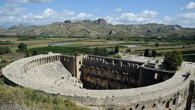
Aspendos Ancient City and Theater
Serik, Antalya
One of Pamphylia's richest cities, with one of the best-preserved Roman theaters of the ancient world.
 Machine translated — This content was machine-translated and may differ from the original Turkish text.
Aqueduct and cistern
Aspendos Aqueduct
Serik, Antalya
A Roman aqueduct that carried water to Aspendos, famous for its pressure towers.
 Machine translated — This content was machine-translated and may differ from the original Turkish text.
Monument and statue
Atatürk Mask
Kepez, Antalya
A giant 35 m relief of Atatürk's face at the entrance to Kepez City Forest.
 Machine translated — This content was machine-translated and may differ from the original Turkish text.
Lake
Avlan Lake
Elmalı, Antalya
A karst lake at 1,030 m formed in the lowest part of the Elmalı Polje.
 Machine translated — This content was machine-translated and may differ from the original Turkish text.
Church
Church of St. Nicholas (Santa Claus)
Demre, Antalya
A Byzantine basilica housing the tomb of St. Nicholas, Bishop of Myra, who inspired the figure of Santa Claus; today a monument museum.
- Machine translated — This content was machine-translated and may differ from the original Turkish text.
Cave
Beldibi Cave
Kemer, Antalya
A Mesolithic rock shelter on the Antalya–Kemer coastal road, at the exit of the Çamdağ tunnel.
 Machine translated — This content was machine-translated and may differ from the original Turkish text.
National park
Beydağları Coastal (Olimpos-Beydağları) National Park
Kemer, Antalya
A national park stretching along the coast from Sarısu to Cape Gelidonya, protecting beaches, ancient cities and cedar forests.
 Machine translated — This content was machine-translated and may differ from the original Turkish text.
Lagoon
Beymelek Lagoon
Demre, Antalya
A coastal lagoon of about 225 hectares east of Demre, where dalyan fishing is practiced.
 Machine translated — This content was machine-translated and may differ from the original Turkish text.
Village and rural life
Bezirgan Yayla and Granaries
Kaş, Antalya
A highland village on the Lycian Way, built on the site of ancient Pirha and known for its traditional wooden granaries.
 Machine translated — This content was machine-translated and may differ from the original Turkish text.
Hammam (Turkish bath)
Çaybaşı Hammam (Bath)
Korkuteli, Antalya
A historic Seljuk hammam in Korkuteli dated to the 13th century.
 Machine translated — This content was machine-translated and may differ from the original Turkish text.
Beach
Çıralı Beach
Kemer, Antalya
A protected 3 km beach, free of development, where Caretta caretta turtles nest.
 Machine translated — This content was machine-translated and may differ from the original Turkish text.
Cave
Damlataş Cave
Alanya, Antalya
A dripstone cave on the west shore of the castle peninsula, discovered in 1948 during quarry blasting.
 Machine translated — This content was machine-translated and may differ from the original Turkish text.
Aqueduct and cistern
Delikkemer (Patara Aqueduct)
Kaş, Antalya
A Roman pressurized water line of pierced stone blocks that carried water to Patara from 22.5 km away.
 Machine translated — This content was machine-translated and may differ from the original Turkish text.
River and spring-fed stream (azmak)
Dim Stream
Alanya, Antalya
A Taurus stream whose cold water, summer and winter, makes it Alanya's spot for cooling off and picnics.
 Machine translated — This content was machine-translated and may differ from the original Turkish text.
Cave
Dim Cave
Alanya, Antalya
A cave with stalactites and stalagmites, open to tourism, on the western slope of Cebireis Mountain overlooking the Dim Valley.
- Machine translated — This content was machine-translated and may differ from the original Turkish text.
Family activity
Dokuma Park and Open-Air Museum
Kepez, Antalya
A city park on the site of the former Antalya Textile Factory, with a miniature museum, a library and museums.
 Machine translated — This content was machine-translated and may differ from the original Turkish text.
Lake
Eğrigöl
Gündoğmuş, Antalya
A mountain lake at about 2,350 m on Söbüçimen Yayla in the Geyik Mountains, called "the Alps of Antalya".
 Machine translated — This content was machine-translated and may differ from the original Turkish text.
Han and caravanserai
Evdir Han
Döşemealtı, Antalya
A Seljuk caravanserai on the Antalya–Isparta caravan route, built in the reign of İzzeddin Keykavus I.
 Machine translated — This content was machine-translated and may differ from the original Turkish text.
Family activity
Expo 2016 Site
Aksu, Antalya
A large park area where the 2016 international horticultural exhibition, Turkey's first Expo, was held.
- Machine translated — This content was machine-translated and may differ from the original Turkish text.
Ancient city
Gagai Ancient City
Kumluca, Antalya
A Lycian coastal city in Mavikent that gave its name to the "gagates" (jet) stone.
- Machine translated — This content was machine-translated and may differ from the original Turkish text.
Caravan site
Gazipaşa Municipality Caravan Park
Gazipaşa, Antalya
A municipal caravan park beside the Fener Recreation Area on Selinti Point.
 Machine translated — This content was machine-translated and may differ from the original Turkish text.
Lighthouse
Gelidonya Lighthouse and Cape Gelidonya
Kumluca, Antalya
The highest lighthouse on Turkey's coasts, at the southern tip of the Teke Peninsula overlooking the Beş Adalar.
 Machine translated — This content was machine-translated and may differ from the original Turkish text.
Climbing area
Geyikbayırı Rock Climbing Area
Konyaaltı, Antalya
A sport climbing area known worldwide for its limestone walls; the Lycian Way also passes through.
 Machine translated — This content was machine-translated and may differ from the original Turkish text.
Lake
Gömbe Yeşil Göl (Akdağ)
Kaş, Antalya
A mountain lake at about 1,990 m near the summit of Akdağ, reached on foot from Gömbe Yayla.
 Machine translated — This content was machine-translated and may differ from the original Turkish text.
Canyon
Göynük Canyon
Kemer, Antalya
A 4.5 km canyon 3–4 km from Göynük village, through which the Lycian Way also passes.
 Machine translated — This content was machine-translated and may differ from the original Turkish text.
National park
Güllük Dağı-Termessos National Park
Korkuteli, Antalya
A national park of about 6,700 hectares established in 1970, protecting Termessos and the forested slopes of Güllük Dağı.
 Machine translated — This content was machine-translated and may differ from the original Turkish text.
Nature park
Güver Canyon Nature Park
Döşemealtı, Antalya
A 115 m deep canyon splitting a travertine plateau; neighbor to a natural habitat of fallow deer.
 Machine translated — This content was machine-translated and may differ from the original Turkish text.
History and archaeology
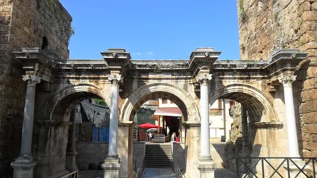
Hadrian's Gate (Üçkapılar)
Muratpaşa, Antalya
A three-arched marble triumphal arch built to commemorate Roman Emperor Hadrian's visit to Antalya in AD 130.
- Machine translated — This content was machine-translated and may differ from the original Turkish text.
Cultural center
Haşim İşcan Cultural Center
Muratpaşa, Antalya
The shared stage of the Antalya State Opera and Ballet and the State Theater.
 Machine translated — This content was machine-translated and may differ from the original Turkish text.
Castle
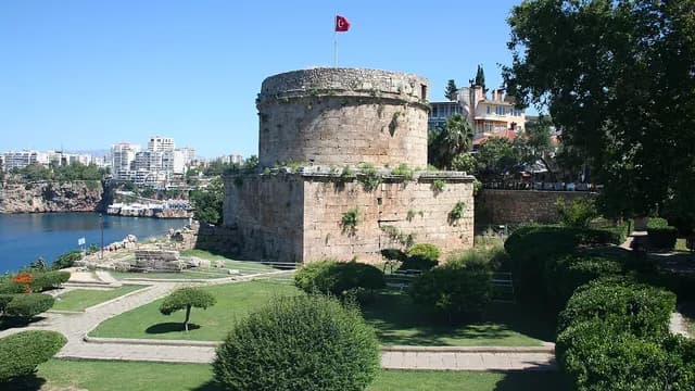
Hıdırlık Tower
Muratpaşa, Antalya
A 2nd-century cylindrical Roman tower overlooking the gulf, where Kaleiçi meets Karaalioğlu Park.
 Machine translated — This content was machine-translated and may differ from the original Turkish text.
Nature park
İncekum Nature Park
Alanya, Antalya
A coastal park in Avsallar known for its shoreline kamenitza formations and an 1,800-year-old olive oil workshop.
 Machine translated — This content was machine-translated and may differ from the original Turkish text.
Ancient city
İotape Ancient City
Alanya, Antalya
A Cilician harbor city built around a small peninsula and cove right beside the Alanya–Gazipaşa road.
 Machine translated — This content was machine-translated and may differ from the original Turkish text.
Architecture
Kaleiçi
Muratpaşa, Antalya
Antalya's walled historic core and its most visited quarter, with narrow streets, bay-windowed houses and slopes leading down to the ancient harbor.
 Machine translated — This content was machine-translated and may differ from the original Turkish text.
Coast and water
Kaleiçi Marina (Historic Harbor)
Muratpaşa, Antalya
A small harbor at the foot of the walls, in use since antiquity; today the gathering place of tour boats and yachts.
 Machine translated — This content was machine-translated and may differ from the original Turkish text.
Coast and water
Kalkan
Kaş, Antalya
An old fishing town whose white houses step down toward the bay, close to Patara and Kaputaş.
 Machine translated — This content was machine-translated and may differ from the original Turkish text.
Beach
Kaputaş Beach
Kaş, Antalya
A small beach on the Kaş–Kalkan road, where a canyon opens onto the sea, famous for its turquoise color.
 Machine translated — This content was machine-translated and may differ from the original Turkish text.
Viewpoint
Karaalioğlu Park
Muratpaşa, Antalya
A large city park just south of Kaleiçi overlooking the Gulf of Antalya and the Beydağları from atop the cliffs.
 Machine translated — This content was machine-translated and may differ from the original Turkish text.
Cave
Karain Cave
Döşemealtı, Antalya
A natural cave, one of Turkey's most important Paleolithic settlements, with a small museum beside it.
 Machine translated — This content was machine-translated and may differ from the original Turkish text.
Han and caravanserai
Kargı Han
Manavgat, Antalya
A historic caravanserai without an inscription in Beydiğin village, north of the Kargı Stream.
 Machine translated — This content was machine-translated and may differ from the original Turkish text.
Island
Kekova Island and Sunken City
Demre, Antalya
An uninhabited island off Kaleköy and Üçağız, famous for the sunken ancient remains along its shore.
 Machine translated — This content was machine-translated and may differ from the original Turkish text.
Mosque
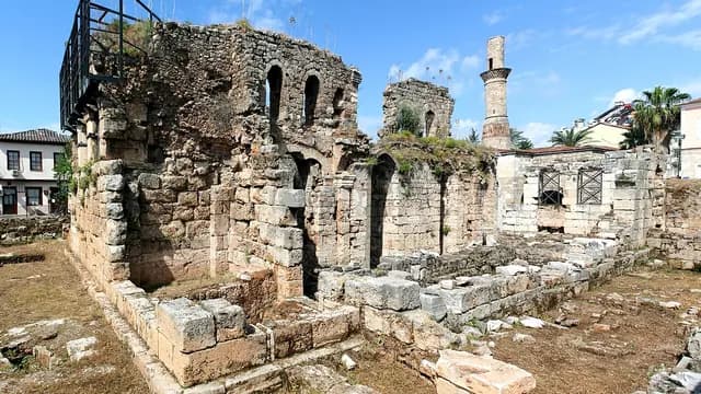
Kesik Minare (Korkut Mosque)
Muratpaşa, Antalya
One of the most interesting buildings in Kaleiçi, with a layered past as a Roman temple turned church turned mosque.
 Machine translated — This content was machine-translated and may differ from the original Turkish text.
Han and caravanserai
Kırkgöz Han
Döşemealtı, Antalya
A Seljuk han built on the Antalya–Isparta road in the reign of Gıyaseddin Keyhüsrev II (1236–1246).
 Machine translated — This content was machine-translated and may differ from the original Turkish text.
Bridge
Kırkgöz Kemeri (Limyra Bridge)
Finike, Antalya
One of the world's oldest segmental-arch bridges, crossing the Alakır Stream with 26 flat arches.
 Machine translated — This content was machine-translated and may differ from the original Turkish text.
Castle
Kızıl Kule (Red Tower)
Alanya, Antalya
An octagonal Seljuk tower rising at the harbor entrance, also featured on Alanya's flag.
 Machine translated — This content was machine-translated and may differ from the original Turkish text.
Blue Flag beach
Kleopatra Beach
Alanya, Antalya
A Blue Flag beach stretching west of the castle peninsula, listed among Europe's best beaches.
- Machine translated — This content was machine-translated and may differ from the original Turkish text.
Monumental tree
Koca Katran and Çığlıkara Cedar Forest
Elmalı, Antalya
A giant monumental Lebanon cedar more than 2,000 years old in the Çığlıkara Nature Conservation Area.
 Machine translated — This content was machine-translated and may differ from the original Turkish text.
Cave
Kocain Cave
Döşemealtı, Antalya
A cave near Ahırtaş, a registered natural monument, with giant halls whose ceilings reach 80 meters in places.
 Machine translated — This content was machine-translated and may differ from the original Turkish text.
Blue Flag beach
Konyaaltı Beach
Konyaaltı, Antalya
A Blue Flag pebble beach stretching for kilometers west of the city, with views of the Beydağları.
 Machine translated — This content was machine-translated and may differ from the original Turkish text.
Rafting
Köprüçay Rafting Route
Manavgat, Antalya
Rafting on the cold, oxygen-rich waters of the Köprü River in Köprülü Canyon National Park.
 Machine translated — This content was machine-translated and may differ from the original Turkish text.
Canyon
Köprülü Canyon National Park
Manavgat, Antalya
A national park protecting the 14 km canyon carved by the Köprüçay, cedar forests and Roman bridges.
 Machine translated — This content was machine-translated and may differ from the original Turkish text.
Bridge
Köprüpazar (Aspendos) Bridge
Serik, Antalya
A zigzag stone bridge built by the Seljuks in the 13th century on the piers of the Roman Eurymedon bridge.
 Machine translated — This content was machine-translated and may differ from the original Turkish text.
Ancient city
Xanthos Ancient City
Kaş, Antalya
The capital of Lycia; the ancient city at Kınık on the UNESCO World Heritage list together with Letoon.
 Machine translated — This content was machine-translated and may differ from the original Turkish text.
Nature park
Kurşunlu Waterfall Nature Park
Aksu, Antalya
A waterfall in a two-kilometer canyon that drops 18 meters and links a series of small pools.
 Machine translated — This content was machine-translated and may differ from the original Turkish text.
Ancient city
Kyaneai Ancient City
Demre, Antalya
One of Lycia's well-preserved inland cities, on the hill above Yavu village, with many sarcophagi and rock tombs.
 Machine translated — This content was machine-translated and may differ from the original Turkish text.
Beach
Lara Beach
Muratpaşa, Antalya
Stretching southeast of the city, one of Antalya's two main beaches along with Konyaaltı.
 Machine translated — This content was machine-translated and may differ from the original Turkish text.
Museum
Museum of Lycian Civilizations
Demre, Antalya
An archaeology museum in the Roman granary at Andriake, telling the history of Lycia.
- Machine translated — This content was machine-translated and may differ from the original Turkish text.
Hiking trail
Lycian Way (Patara–Gelemiş Section)
Kaş, Antalya
The Patara section of Turkey's first waymarked long-distance hiking route, running from Fethiye to Antalya.
 Machine translated — This content was machine-translated and may differ from the original Turkish text.
Ancient city
Limyra Ancient City
Finike, Antalya
An impressive ancient city at the foot of the Taurus, once one of Lycia's royal capitals, with its theater and rock tombs.
 Machine translated — This content was machine-translated and may differ from the original Turkish text.
Reservoir and pond
Manavgat Reservoir
Manavgat, Antalya
A reservoir on the Manavgat River, downstream of Oymapınar.
 Machine translated — This content was machine-translated and may differ from the original Turkish text.
Waterfall
Manavgat Waterfall
Manavgat, Antalya
A waterfall just north of the district center where the Manavgat River tumbles exuberantly over a low step across a wide area.
 Machine translated — This content was machine-translated and may differ from the original Turkish text.
Nature park
Mavikent Nature Park
Kumluca, Antalya
A 42-hectare nature park on the Mavikent coast in Kumluca, where pine and acacia forest created by dune afforestation meets the beach.
 Machine translated — This content was machine-translated and may differ from the original Turkish text.
Mosque
Murat Paşa Mosque
Muratpaşa, Antalya
A classical-period Ottoman mosque built in 1570 that gave its name to the district.
 Machine translated — This content was machine-translated and may differ from the original Turkish text.
Rock tomb
Myra Ancient City
Demre, Antalya
An ancient city famous for its house-type Lycian tombs carved into sheer cliffs overlooking the Demre plain and its Roman theater.
 Machine translated — This content was machine-translated and may differ from the original Turkish text.
Bridge
Oluk Bridge (Selge Eurymedon Bridge)
Manavgat, Antalya
A Roman bridge still in use, crossing the Köprüçay with a single arch at valley height.
 Machine translated — This content was machine-translated and may differ from the original Turkish text.
Ancient city
Olympos Ancient City
Kumluca, Antalya
A Lycian city in a deep valley, spread along a stream running to the seashore and intertwined with the forest.
 Machine translated — This content was machine-translated and may differ from the original Turkish text.
Mosque
Ömer Paşa Mosque and Complex
Elmalı, Antalya
The largest Ottoman mosque in the Antalya region, commissioned by Ketenci Ömer Paşa in the early 17th century.
 Machine translated — This content was machine-translated and may differ from the original Turkish text.
Village and rural life
Ormana Village and Erymna
İbradı, Antalya
A mountain village built on the remains of the ancient city of Erymna, famous for its "düğmeli ev" architecture.
 Machine translated — This content was machine-translated and may differ from the original Turkish text.
Reservoir and pond
Oymapınar Reservoir
Manavgat, Antalya
A turquoise lake formed by a 185-meter arch dam in the deep valley of the Manavgat River.
 Machine translated — This content was machine-translated and may differ from the original Turkish text.
Ancient city
Patara Ancient City
Kaş, Antalya
The harbor city where St. Nicholas was born, known for the assembly building of the Lycian League.
 Machine translated — This content was machine-translated and may differ from the original Turkish text.
Lighthouse
Patara Lighthouse
Kaş, Antalya
A Roman lighthouse built under Nero (AD 64), one of the few from antiquity that could be faithfully restored.
 Machine translated — This content was machine-translated and may differ from the original Turkish text.
Beach
Patara Beach
Kaş, Antalya
A shallow, fine-sand beach about 18 km long surrounded by dunes; a nesting area for sea turtles.
 Machine translated — This content was machine-translated and may differ from the original Turkish text.
Ancient city
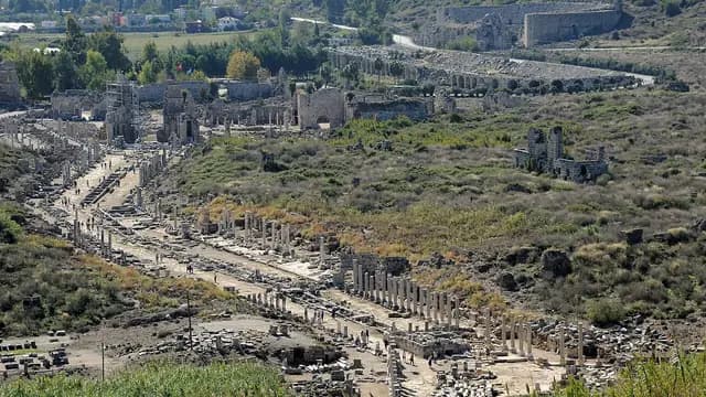
Perge Ancient City
Aksu, Antalya
Once the capital of Pamphylia, one of the region's most magnificent ancient cities, with its colonnaded street, Hellenistic gates and stadium.
 Machine translated — This content was machine-translated and may differ from the original Turkish text.
Ancient city
Phaselis Ancient City
Kemer, Antalya
A Lycian harbor city among pine forests, with three harbors, an aqueduct and a main street running down to the shore.
 Machine translated — This content was machine-translated and may differ from the original Turkish text.
Ancient city
Rhodiapolis Ancient City
Kumluca, Antalya
A compact Roman-era Lycian city planned on narrow terrain on a hill 2.5 km north of Kumluca.
 Machine translated — This content was machine-translated and may differ from the original Turkish text.
Ski resort
Saklıkent Ski Center
Konyaaltı, Antalya
A ski center on the northern slope of Bakırlıdağ in the Beydağları, about 50 km from the sea.
 Machine translated — This content was machine-translated and may differ from the original Turkish text.
Canyon
Sapadere Canyon
Alanya, Antalya
A karst canyon in Sapadere village with walls 400 meters high, entered via a wooden walkway.
 Machine translated — This content was machine-translated and may differ from the original Turkish text.
Han and caravanserai
Şarapsa Han
Alanya, Antalya
A Seljuk caravanserai 15 km west of Alanya, built in the reign of Gıyaseddin Keyhüsrev II.
 Machine translated — This content was machine-translated and may differ from the original Turkish text.
Picnic area
Sarısu Recreation Area
Konyaaltı, Antalya
A seaside recreation area under pine trees at the western end of Konyaaltı beach.
- Machine translated — This content was machine-translated and may differ from the original Turkish text.
Hammam (Turkish bath)
Sefa Hammam (Bath)
Muratpaşa, Antalya
A historic hammam in the narrow streets of Kaleiçi, dating to the Seljuk period.
 Machine translated — This content was machine-translated and may differ from the original Turkish text.
Architecture
Seljuk Hunting Lodge
Kemer, Antalya
One of the three known Seljuk hunting lodges, in the forest at the entrance to Kemer, dated to 1230–1248.
 Machine translated — This content was machine-translated and may differ from the original Turkish text.
Ancient city
Seleukeia (Lyrbe) Ancient City
Manavgat, Antalya
A Pamphylian mountain city near Bucakşeyhler in a pine forest, with a well-preserved agora and baths.
 Machine translated — This content was machine-translated and may differ from the original Turkish text.
Ancient city
Selge Ancient City
Manavgat, Antalya
A Pisidian mountain city at 1,250 meters in the Taurus, intertwined with Altınkaya village.
 Machine translated — This content was machine-translated and may differ from the original Turkish text.
Ancient city
Selinus Ancient City and Gazipaşa Castle
Gazipaşa, Antalya
A Cilician harbor city where Roman Emperor Trajan died in 117, spread over the hill and beach at the mouth of the Musa Stream.
 Machine translated — This content was machine-translated and may differ from the original Turkish text.
Ancient city
Side Ancient City
Manavgat, Antalya
One of the best-known cities of the classical period, with a theater, agora and wall gates intertwined with modern Side on the peninsula.
 Machine translated — This content was machine-translated and may differ from the original Turkish text.
History and archaeology
Temple of Apollo, Side
Manavgat, Antalya
A 2nd-century AD Roman temple at the tip of the peninsula, its five columns rising against the sea.
 Machine translated — This content was machine-translated and may differ from the original Turkish text.
Museum
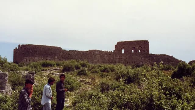
Side Museum
Manavgat, Antalya
A museum established by restoring a Roman bath complex, displaying finds from the Side excavations.
 Machine translated — This content was machine-translated and may differ from the original Turkish text.
Ancient city
Sillyon Ancient City
Serik, Antalya
A Pamphylian hill-fortress city built on a flat-topped rock mass between Perge and Aspendos.
 Machine translated — This content was machine-translated and may differ from the original Turkish text.
Castle
Simena (Kaleköy)
Demre, Antalya
A village opposite Kekova, reached only by sea or footpath, with its hilltop castle and Lycian sarcophagi submerged in the sea.
- Machine translated — This content was machine-translated and may differ from the original Turkish text.
Hiking trail
St. Paul Trail Start (Perge)
Aksu, Antalya
The starting point at Perge of the St. Paul Trail, a long-distance hiking route of about 500 km from Perge to Yalvaç.
- Machine translated — This content was machine-translated and may differ from the original Turkish text.
Cave
Suluin Cave
Finike, Antalya
A deep vertical underwater cave just above the Finike–Kaş road, known for its 80-meter mouth.
 Machine translated — This content was machine-translated and may differ from the original Turkish text.
Museum
Suna-İnan Kıraç Kaleiçi Museum
Muratpaşa, Antalya
A private ethnography and art museum in a restored Orthodox church and a traditional Kaleiçi house.
 Machine translated — This content was machine-translated and may differ from the original Turkish text.
Ancient city
Syedra Ancient City
Alanya, Antalya
A harbor city between Alanya and Gazipaşa, built on a slope facing the sea and dating back to the 7th century BC.
 Machine translated — This content was machine-translated and may differ from the original Turkish text.
Summit
Tahtalı Dağı (Lycian Olympos)
Kemer, Antalya
A mountain rising right behind the Kemer coast, whose 2,365 m summit can also be reached by cable car.
 Machine translated — This content was machine-translated and may differ from the original Turkish text.
Canyon
Tazı Canyon (Bilgelik Vadisi)
Manavgat, Antalya
A canyon in Köprülü Canyon National Park famed as a viewing terrace for its sheer 300–400 meter walls.
 Machine translated — This content was machine-translated and may differ from the original Turkish text.
Rock tomb
Teimiussa and Üçağız
Demre, Antalya
A small Lycian harbor settlement on the shore right beside Üçağız village, with sarcophagi and rock tombs.
 Machine translated — This content was machine-translated and may differ from the original Turkish text.
Mosque
Tekeli Mehmet Paşa Mosque
Muratpaşa, Antalya
An Ottoman-era mosque at Kalekapısı, right next to the Clock Tower.
- Machine translated — This content was machine-translated and may differ from the original Turkish text.
Nature park
Tekirova Nature Park
Kemer, Antalya
A 12-hectare nature park around Kleopatra Cove in Tekirova, protecting a 390-meter strip of coast where sea and forest meet.
 Machine translated — This content was machine-translated and may differ from the original Turkish text.
Ancient city
Termessos Ancient City
Döşemealtı, Antalya
A Pisidian city hidden among pine forests on the slope of Güllük Dağı at about 1,000–1,150 m.
 Machine translated — This content was machine-translated and may differ from the original Turkish text.
Ancient city
Trebenna Ancient City
Konyaaltı, Antalya
An ancient city on the Lycia–Pamphylia border, built on a mountain slope near Geyikbayırı.
- Machine translated — This content was machine-translated and may differ from the original Turkish text.
Island
Üç Adalar (Three Islands)
Kemer, Antalya
Small islets off Tekirova offering world-class dive sites.
 Machine translated — This content was machine-translated and may differ from the original Turkish text.
Monument and statue
Ulusal Yükseliş Anıtı (National Rise Monument)
Muratpaşa, Antalya
Hüseyin Gezer's 1964 Atatürk monument on Cumhuriyet Square.
 Machine translated — This content was machine-translated and may differ from the original Turkish text.
Nature
Yanartaş (Chimaera)
Kemer, Antalya
Flames near Çıralı that have burned unextinguished for thousands of years from gas vents in the rocks.
 Machine translated — This content was machine-translated and may differ from the original Turkish text.
Mosque
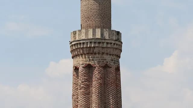
Yivli Minare Mosque
Muratpaşa, Antalya
A 13th-century Seljuk monument that has become Antalya's symbol, with its fluted brick minaret at the entrance to Kaleiçi.
 Machine translated — This content was machine-translated and may differ from the original Turkish text.
Waterfall
Upper Düden Waterfall
Kepez, Antalya
A waterfall near Varsak where the Düden River pours down in a wooded park, which you can walk behind.
 Machine translated — This content was machine-translated and may differ from the original Turkish text.
Cave
Zeytintaşı Cave
Serik, Antalya
A two-level karst cave in Akbaş village known for its soda straw stalactites, opened to tourism in 2002.
Practical information
Machine translated — This content was machine-translated and may differ from the original Turkish text.- Skiing
- Saklıkent Ski Center, December–April depending on snow conditions
- Climate
- Hot, dry summers and mild, rainy winters on the coast (Mediterranean climate); continental influence inland and in the yaylas
- Best season
- April–June and September–November; May–October for the sea, June–September for the yaylas
- Museum pass
- Müzekart (Museum Pass) is valid at Ministry museums and archaeological sites
- Getting there
- Antalya Airport (~13 km from the center) and Gazipaşa-Alanya Airport; the D400 coastal road within the province and tram lines in the city
- Long-distance hiking
- Lycian Way, marked in red and white; spring and autumn are recommended